by
CHAM - MEI, Moscow Power Engineering Institute
Paper at Phoenics User Conferences, March 1996, in Atlanta, Georgia, USA, and April 1996 in Tokyo, Japan
A model has been developed for simulating the transport and mixing of pollutants in natural water streams. It is intended primarily for studies of the fate and transport of spilled oil in rivers.
The model is based on PHOENICS; and its built-in options are extended to physical processes relevant to both open-surface and ice-covered conditions.
The model has been validated against both model-scale experiments and full-scale field observations in natural rivers.
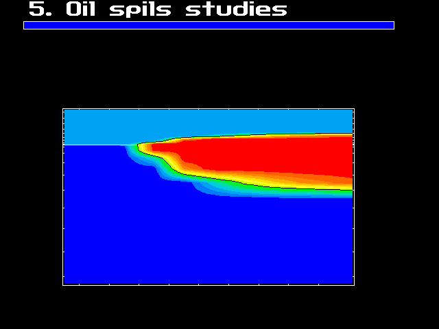
Oil spills on inland rivers can have enormous environmental impacts. The models are
valuable for clarifying the movement of an oil slicks, affecting the aquatic environment
for fish and wild life and water-supply intakes along the river.
Numerous spill models have been developed for coastal marine environments. The most comprehensive model for river spills includes over-simplified flow models which failed to describe the water currents in the complex river course structures and have not been extensively validated [1].
The purpose of the present work is to develop a model integrating all major oil-spill transportation mechanisms that meets the above needs into the PHOENICS computer [2] system and to validate it against the existing and specially conducted measurements and field observations.
When oil ( or other chemicals and pollutants) is spilled into a river, computer simulation system should be used as a tool to predict the water quality in terms of pollutant concentrations over the time and space concerned:
A pictorial example of the environmentalist's needs now follows.
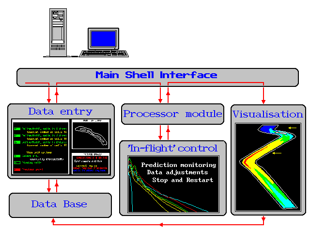
To meet these needs the integrated model system is designed. ROSA ( River Oil Spill Analyser) has been developed by CHAM-MEI as a PHOENICS add-on for computing the spread of oil on river surfaces after a spill. It is comprised of a series of linked submodels and data bases. It has the following modules which are connected through the menu system:
In the model presented here, oil pollutants in the river are considered to consist of:
There exist the continuous exchange between the two layers and mass losses to the atmosphere. The thickness of the surface layer is assumed to be much less than that of the suspended layer, which is equal to the flow depth.
Two layer pollutant treatment
Surface oil slick
Suspended layer
The water currents are computed on the base of the number of formulations which reflects the nature of the flow in the river section in question as follows :
Oil slick transformation processes considered for this part of the stream include:
The oil concentration distribution in the mixed layer containing suspended oil fragments is described by conservation equations considering the mechanisms of:
The most important property of any model is its ability to predict actual situations.
The most serious shortcomings of most of the spill models to date has been the lack of testing.
Testing the model should be part of the model creation.
In this section, number of comparisons between the calculations and specially conducted experiments and field exercises will be presented.
This section begins with a number of comparisons with reliable laboratory and field measurements of a velocity fields and free surface elevations in two- and three-dimensional sections of open channels and river courses.
The applications for spill exercises for real natural river conditions will follow next.
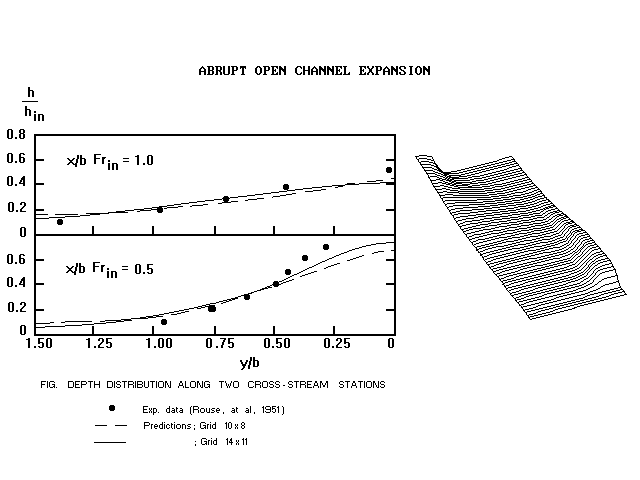
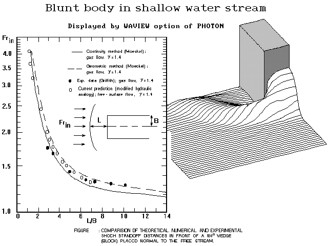
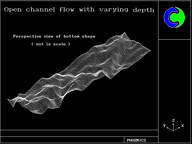
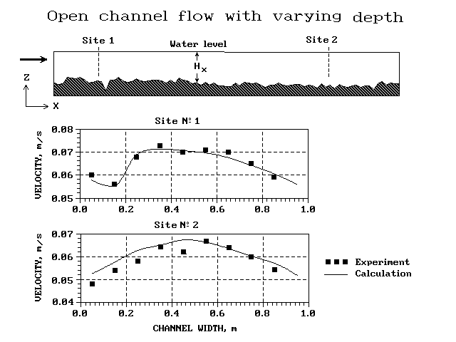
The number of sub- and super-critical free-surface flows have been calculated. Different bed shapes and plane geometries have been considered. They include :
The good agreement has been achieved both for free-surface elevation and velocity distributions.
Pictorial extracts from the study now follow.
Blunt body in shallow water stream
Open channel flow with varying depth(bottom)
Open channel flow with varying depth(width)
/phoenics/d_polis/d_enc/d_pcx/sv_meand
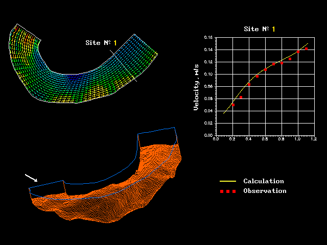
The next step in validation program was to compare the measured velocity distributions with calculated profiles for the typical river situations presented by down scaled hydraulic models.
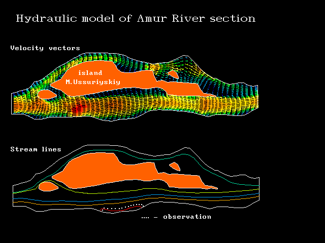
The example which follows next is for the scaled section of River Amur of Russian Far East.
The picture presents the calculated vector velocity field and water currents visualised by stream lines. In most cases the overall agreement has proved to be good.
Hydraulic model of Amur River section
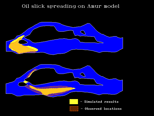
A number of oil-slick-movement studies have also been carried out for scaled river models.
The photos of oil slicks at different time moments compared favourably with the locations and shapes of predicted slicks.
An example of the comparison will be shown on the next panel.
The scaled model in question is again the River Amur section just presented for velocity fields.
Oil slick spreading on Amur model
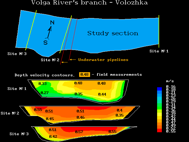
The considerable attention has been given for comparison model velocity fields with data of hydrological field measurements in real river conditions. Two examples illustrate rather typical comparisons.
The simulated contours of velocity vector magnitudes for three cross sections of the reach of the Volga River's branch Volozhka are shown in next panel. The model employed the three-dimensional BFC option.
The numbers in the contour fields represent the field measurements. Calculated velocity vectors are found to compare favorably with data obtained in the field for the conditions of summer flow in 1993.
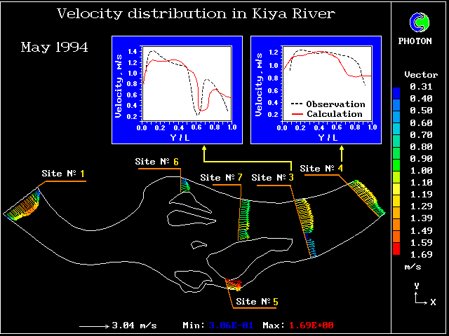
The two-dimensional shallow water option has been used to calculate the flow currents in the section of the Kiya River of West Siberia, see next panel , for the summer flow disharge of 1994. To simulate the highly varying depth, the coast line geometry, the presence of dams and islands shapes the BFC option is used in all directions.
The agreement between the field measurement of the velocity magnitudes and the predicted profiles is found to be very reasonable.
Velocity distribution in Kiya River
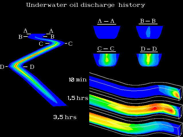
In this example, a hypothetical underwater spill is simulated.
A two-phase version has been used in this case of typical transient flow of buoyant oil fragments.
The model is 3-dimensional and the BFC option is used to represent the shapes of river course and its bed. The calculations include the effect of buoyancy, bottom and internal frictions.
Underwateroil discharge history
The case above was simulated to illustrate the three-dimensional effects of unsteady spatial distribution of the oil concentration in the water body.
The pictures show the history of oil concentration field under influence of buoyancy, flow discharge and the river course.
Experiments are now in progress to make comparisons with predicted fields.
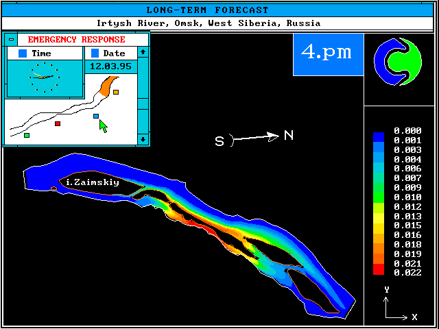
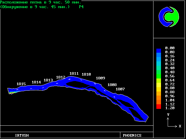
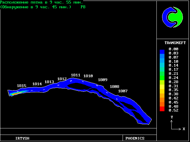
To study the predictive capability of the model, two field exercises were carried out in the summers of 1994 and 1995 on two rivers of West Siberia : River Kiya and River Irtysh.
The observed data available are for the time of slick arrival to the marks, for the leading edge of the oil slick along the river, slick length, slick width and the distance of the slick centre from the left bank.
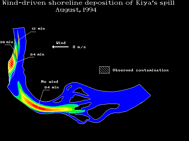
The next picture presents the slick locations and contamination areas for two cases as :
(a) the wind blowing in indicated direction at 8 mps and (b) no-wind conditions
As shown the resulting impact of the two cases is very different. In case (a) most of the oil hits the right shore and slowly leaks back into the water.
The model results agree remarkably well with observed location of contamination area.
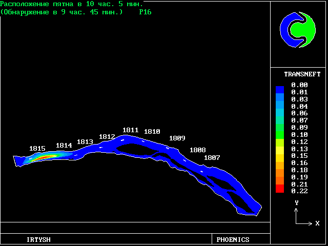
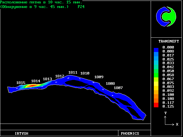
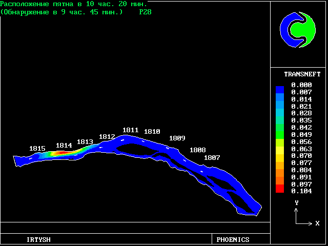
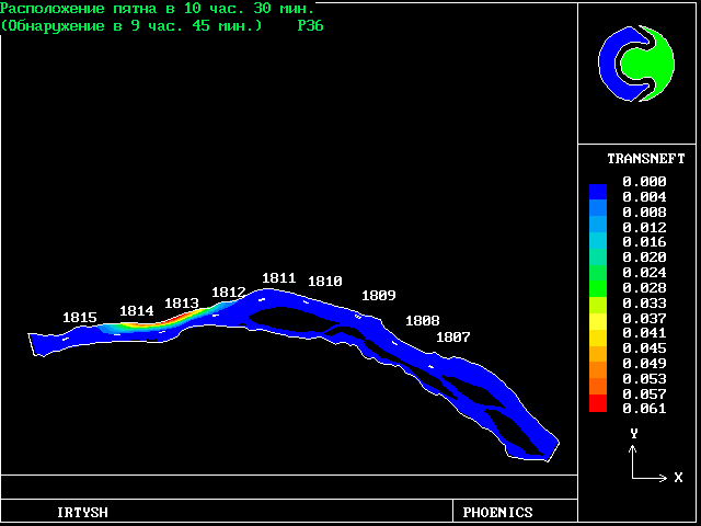
The movement of oil on the surface of the River Irtysh subsequent to a spill for a wind conditions is shown on the next panels.
The wind of 7mps is blowing from left down corner.
Pictures are as follows:
Oil concentration after 5 min,
10 min ,
15 min ,
30 min ,
35 min ,
40 min ,
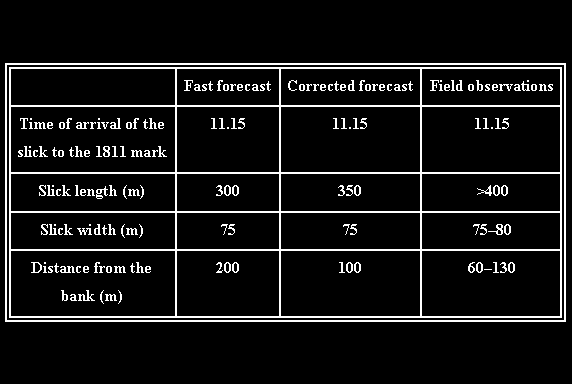
The following page contains a table showing comparisons between field measurements made at the Irtysh River on 15th August 1995 and simulated results.
Two simulations were made, a quick forecast and a longer calculation. Both simulations were carried out before the results were known, but with knowledge of the wind conditions.
The predicted results are in good agreement with the measurements, although the length of the slick is underpredicted. The time for the slick to arrive at a fixed point downstream was predicted very accurately.
Table. Note that 11.15 means 11.15 am
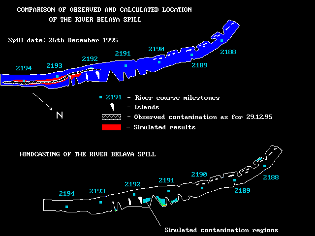
This is the last example of the series. It is concerned with the oil spill that recently occurred in the Belaya River on December 26, 1995.
The predictions were based on the set of reported data available. They include the spill time and period, spill discharge, river flow discharge, river geometry and bottom topography. The ambient temperature was low enough for water to be ice-covered.
The observed data available are for the leading edge of the slick and the location of slick contamination area.
The upper picture on the previous panel shows the observed and predicted slick location 3 days later after the spill.
The bottom picture shows the simulated peak oil concentration in the suspension.
Considering that the data did not clearly indicate at what hour of the day they were collected, the comparison seems to be good enough for many practical needs.
The basic principles and modelling features of ROSA, a model system for river oil-spill studies, have been presented.
The oil-spill model based on PC PHOENICS has been developed, validated and applied to the number of scaled and field exircises on natural rivers and for actual spills.
The model contains all major oil-spill transportation mechanisms, is user friendly, and integrates all aspects of simulation.
The examples of applications show good agreement with observed data and demonstrate the usefullness of the oil- spill simulation model in emergencies.
Although developed for oil-spill simulation, the model can also be used for the simulations of chemical spills in rivers.
1 Shen, H. T., and P. D. Yappa, 1988, Oil slick transport in rivers., Journal of Hydraulic Engineering, American Society of Civil Engineering, v 114, N 5, pp 529-543
2 D. B. Spalding, 1981, A general-purpose computer program for multi-dimensional one- and two-phase flow., Journal of Mathematics and Computings in Simulation,, 23
3 S. V. Zhubrin, 1995, The computer simulation in forecasting effects of oil disharge accidents on the underwater pipelines, Oil pipeline transport, N 5, pp 20-30.
wbs